

On board NOAS ark
SuperyachtNews.com heads to Plymouth, UK, to try out Sonardyne's Navigation and Obstacle Avoidance System (NOAS) - a new sonar unit that builds a 3D picture of the seabed and hazards in real time.…
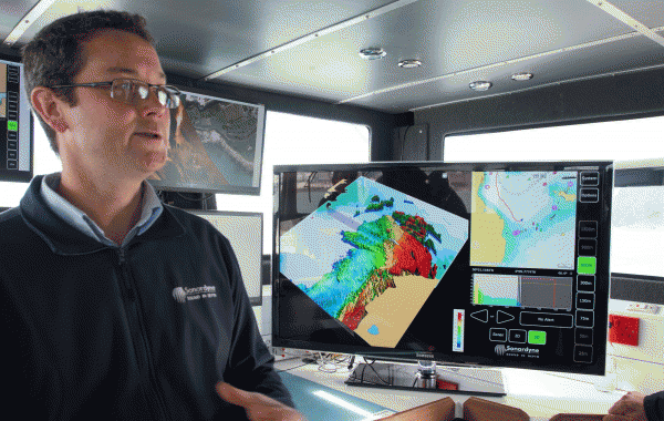
The sun sits high in the Spring sky as we head down the pontoons at Plymouth's Mayflower Marina. We are heading for Sonardyne's 11m motor cat, which is laden with test rigs that show the capabilities of the company's technologies. In particular, it is fitted with NOAS - Sonardyne's new 'Navigation and Obstacle Avoidance Sonar' . It offers users not only a radar-like traditional sonar view of upcoming underwater obstructions, but also 2D and 3D colour modes in which a full colour picture of the seabed and surrounding hazards is generated in real time.
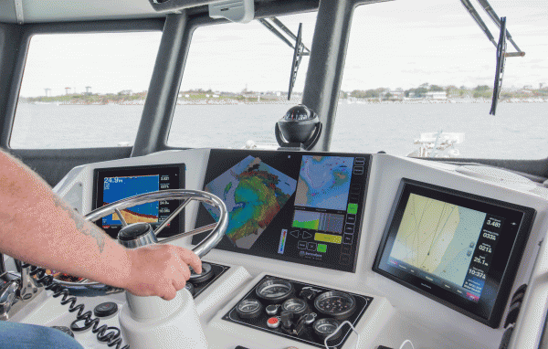
As we cast off, the NOAS unit is first switched to conventional sonar mode, in which a radar-like image is projected on the electronic chart. We quickly switch to 2D mode, which shows a top-down view as our vessel tracks away from the pontoons into the Sound. Depths are shown by colour and the picture slowly builds up around us as the information from the 90-degree cone of the scan is gathered as the yacht's heading changes.
The display shows not only the main NOAS scan screen, but also a smaller top-down chart with vessel track that indicates how much of the historical data is being stored. In addition, a profile-like bar displaying the approaching seabed profile on current heading offers an additional degree of security. User-defined caution and critical alarms notify of potential dangers and don't-go depths. What is also interesting is that as the image builds, parts are left blank until the scan and software are sure that the information is correct - there is no interpolation algorithm that could lead to potential misinformation. Even so, the image builds quickly, particularly at speeds of a few knots or less which is the most likely useful operating window of the NOAS system for navigation.
Finally, we switch to 3D mode, which uses the same depth-colour coding as the 2D display, but which brings the seabed and other obstructions to life. The image can be manipulated through the touchscreen on both the horizontal and vertical axes, and so detailed is the picture that navigation buoys appear as impassable columns from the surface. Even more impressively, several thin diagonal lines appear as we skirt past a long pontoon - the mooring chains that are holding the pontoon in place.
It's not difficult to see where the NOAS system could prove invaluable. Three years ago I cruised the Raja Ampat archipelago in Indonesia on a 49m yacht, but with inaccurate or non-existent charts, nosing into the myriad bays and atolls was a test of nerve and daring. With NOAS, it would have been a simple operation to detect safe passages and anchorages, and also to back out of trouble if we had found our way blocked. Indeed, NOAS has already been fitted to its first superyacht - a recently launched 140m+ vessel from a well known yard.
While the size of the sonar transponder equipment suggests NOAS is better suited to the biggest vessels - the in-water unit will typically be built as a large cartridge that will slide into a corresponding cavity in a bulbous bow - Sonardyne are currently actively targeting the 70m+ yacht market.
The NOAS system currently costs around £270,000, with a further £20,000 to £30,000 in additional engineering to tailor the installation to a specific superyacht. More importantly, the current preferred location for the sonar unit - in the bulb - means that ideally consideration should be given right at the design stage of the yacht. It should also be possible to fit a second unit somewhere towards the stern of the yacht which could give a complete ahead-astern solution.
However, while Sonardyne is already looking at ways to reduce the form factor of the transponder unit as technology advances, the system is already a fascinating addition to the arsenal of navigation aids on a modern bridge. Aside from being utterly mesmerising to watch as the topography is revealed in 3D, it has practical considerations that could prove invaluable for any yacht heading into shallow or uncharted waters where bottom depth and potential obstructions are either not clear or not known.
NEW: Sign up for SuperyachtNewsweek!
Get the latest weekly news, in-depth reports, intelligence, and strategic insights, delivered directly from The Superyacht Group's editors and market analysts.
Stay at the forefront of the superyacht industry with SuperyachtNewsweek
Click here to become part of The Superyacht Group community, and join us in our mission to make this industry accessible to all, and prosperous for the long-term. We are offering access to the superyacht industry’s most comprehensive and longstanding archive of business-critical information, as well as a comprehensive, real-time superyacht fleet database, for just £10 per month, because we are One Industry with One Mission. Sign up here.
NEW: Sign up for
SuperyachtNewsweek!
Get the latest weekly news, in-depth reports, intelligence, and strategic insights, delivered directly from The Superyacht Group's editors and market analysts.
Stay at the forefront of the superyacht industry with SuperyachtNewsweek